Trail On foot Les Vigneaux - Entre Parapin et Gyronde - Photo

Tous les sentiers balisés d’Europe PRO

© OpenStreetMap contributors
Length
Length
5.8 km
Max alt
Max alt
1249 m
Uphill gradient
Uphill gradient
184 m
Km-Effort
Km-Effort  
8.3 km
Min alt
Min alt
1079 m
Downhill gradient
Downhill gradient
191 m
Boucle
Boucle
Yes
Signpost
Signpost
Creation date :
2022-02-15 19:22:50.195
Updated on :
2022-03-02 23:51:22.537

(0 Reviews)

On foot
On foot
1h53
Difficulty : Easy

Scan this QR Code to open this trail in the SityTrail application

FREE GPS app for hiking

Logo SityTrail SityTrail

IGN / Geographical institutes

Download SityTrail from the App Store Download SityTrail from Google Play

Logo SityTrail SityTrail World

The world is yours!

Download SityTrail from the App Store Download SityTrail from Google Play Download SityTrail on Huawei AppGallery

About

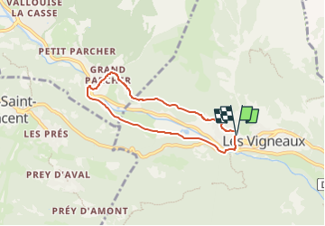
Trail On foot of 5.8 km to be discovered at Provence-Alpes-Côte d'Azur, Hautes-Alpes, Les Vigneaux. This trail is proposed by SityTrail - itinéraires balisés pédestres.

Description

Trail created by Communauté de communes du Pays des Ecrins.

Photos

Positioning

Country:
France
Region :
Provence-Alpes-Côte d'Azur
Department/Province :
Hautes-Alpes
Municipality :
Les Vigneaux
Location:
Unknown
Start:(UTM)
305282 ; 4966400 (32T) N.

Trails nearby

Trail Walking Puy-Saint-Vincent - La tête d'Oreac - Photo
Walking
Sigmut

Walking

Easy
(1)
Puy-Saint-Vincent, Provence-Alpes-Côte d'Azur, Hautes-Alpes, France
6 km | 10.4 km-effort
3h 55min
Yes
Trail Walking Puy-Saint-Vincent - Cascades de Narreyroux - Puy Saint Vincent - Photo
Walking
tracegps

Walking

Difficult
(1)
Puy-Saint-Vincent, Provence-Alpes-Côte d'Azur, Hautes-Alpes, France
11.4 km | 19.2 km-effort
4h 0min
Yes
Trail On foot Vallouise-Pelvoux - Boucle vers Puy Aillaud - Photo
On foot
PRO

On foot

Easy
Vallouise-Pelvoux, Provence-Alpes-Côte d'Azur, Hautes-Alpes, France
5.3 km | 10.2 km-effort
2h 19min
No
Trail On foot Vallouise-Pelvoux - Boucle de Pelvoux - Photo
On foot
PRO

On foot

Easy
Vallouise-Pelvoux, Provence-Alpes-Côte d'Azur, Hautes-Alpes, France
12.2 km | 18.7 km-effort
4h 15min
Yes
Trail On foot Vallouise-Pelvoux - Boucle de Vallouise - Photo
On foot
PRO

On foot

Easy
Vallouise-Pelvoux, Provence-Alpes-Côte d'Azur, Hautes-Alpes, France
8.1 km | 11.6 km-effort
2h 38min
Yes
Trail On foot Les Vigneaux - Tour des Vigneaux - Photo
On foot
PRO

On foot

Easy
Les Vigneaux, Provence-Alpes-Côte d'Azur, Hautes-Alpes, France
5.7 km | 7.5 km-effort
1h 42min
Yes
Trail Snowshoes Puy-Saint-Vincent - la tête d'Oréac - Photo
Snowshoes
GUIDE
amiral13

Snowshoes

Medium
Puy-Saint-Vincent, Provence-Alpes-Côte d'Azur, Hautes-Alpes, France
6.4 km | 11.4 km-effort
4h 7min
Yes
Trail Walking Puy-Saint-Vincent - le lac des Hermes - Photo
Walking
GUIDE
amiral13

Walking

Easy
Puy-Saint-Vincent, Provence-Alpes-Côte d'Azur, Hautes-Alpes, France
4.3 km | 6.5 km-effort
3h 9min
Yes
Trail Walking Puy-Saint-Vincent - Narreyroux au départ de PSV 1600 - Photo
Walking
GUIDE
amiral13

Walking

Very easy
Puy-Saint-Vincent, Provence-Alpes-Côte d'Azur, Hautes-Alpes, France
4.6 km | 6.3 km-effort
1h 49min
Yes


Close
My subscriptions